
Land Development
Land development and surveying cover diverse projects, ranging from small property improvements to large-scale subdivisions and building constructions.
Land development and surveying can mean any change / improvement to a residential, industrial or commercial property and can vary from planning to build a new carport at the front of your property to subdividing a super lot into over 100 individual residential lots, to building a multi storey building to create a built strata with a mix of commercial and residential.
McGregor Surveys can provide land surveying and project management services to meet all of these needs.
Below is a list of surveying services we can offer you, backed up by our project management team to provide a one stop shop for your development.
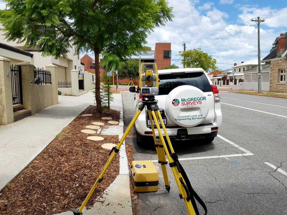
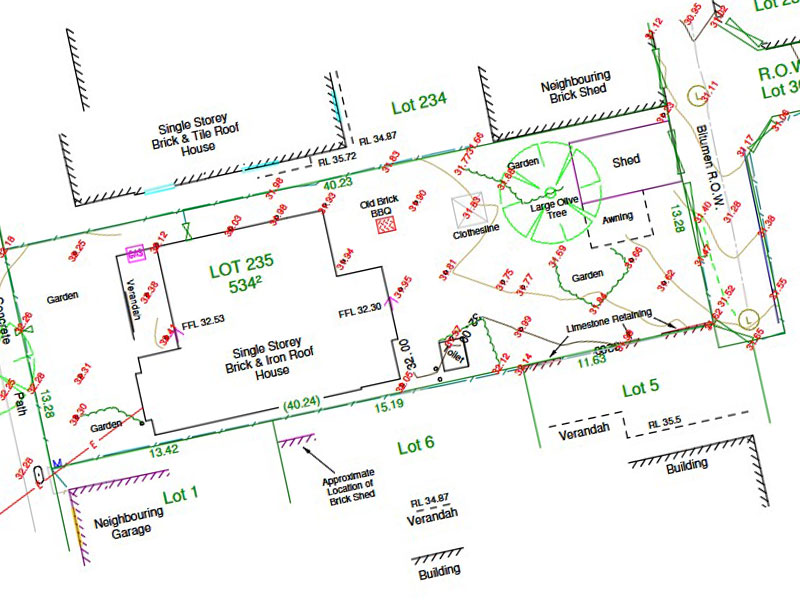
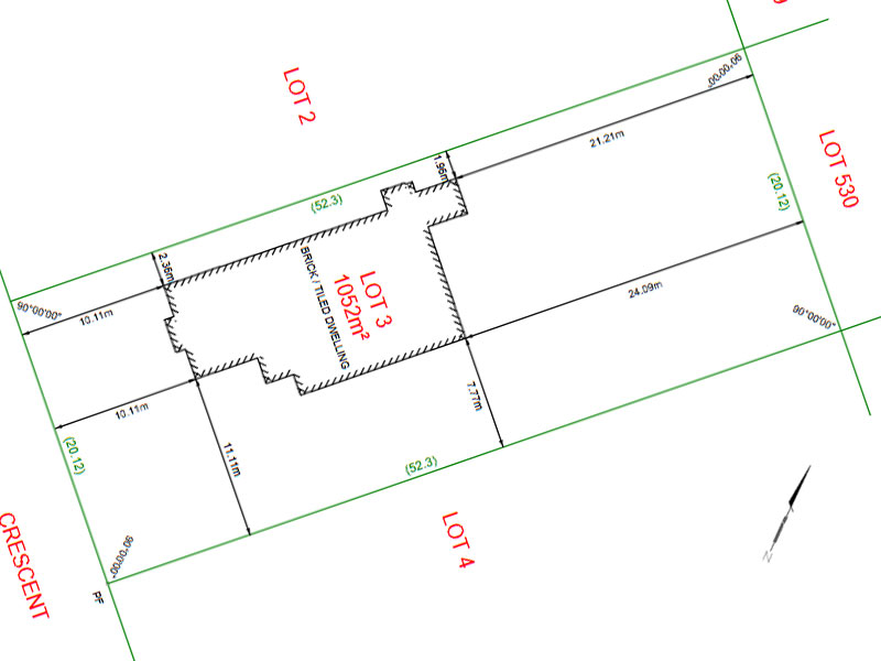
Contour and Feature Survey
A contour and feature survey is the first requirement for any:
- Subdivision application to the Western Australian Planning Commission (WAPC) requirements, for any improvement on your residential, industrial, commercial or rural lot to the local shire requirements.
- Engineering design – roads, drainage, powerlines, sewer, water, dams, pipelines
- Architectural design for residential, commercial, industrial – demolish and rebuild, extension to existing houses, greenfield development or brownfield development
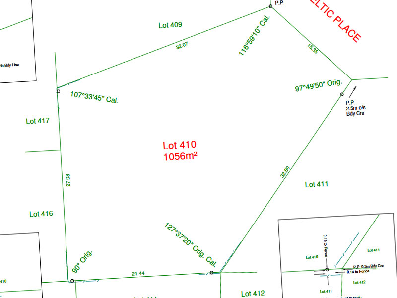
Boundary Re-Establishment Survey (Repeg)
A boundary re-establishment survey or repeg, as it is commonly referred to, can be used for the following purposes:
- For fence installation on the true boundary
- Building set out
- Boundary disputes
- Install a retaining wall
- Building a parapet wall on the boundary
- Western Power requirement for installation of underground power dome.
- Commercial construction where it is a requirement under the contract to conduct this service
With any boundary re-establishment survey, a regulation 25A certificate will be sent to the client showing the location of all marks placed, with respect to the boundary.
Building Set Out
A building set out is to mark out the true position of the building with respect to the lot boundary.
This is particularly important if any portion of the building or garage is being constructed on the boundary.
Marks can be placed to be right on the building changes of directions or offset to allow for the construction of the building. A building sketch is then created to confirm the true locations of the marks placed and passed onto the client.
Identification Survey
If you need to know the location of your house, shed, garage, fences or any other structure with respect to the boundary, this is called an identification survey.
This survey will quote distances to any structure on your property and a regulation 25A certificate (drawing) will be sent to the client showing all dimensions from any structure requested.

Subdivision
Subdivisions can be categorised in three ways.
Green Title Subdivision
Survey Strata Subdivision
Built Strata Subdivision
How we help
If you are planning to conduct any development on your property, we can guide you through this process by assisting you with:
- Preparing a feasibility study to ensure you understand all costs that are involved in developing your land.
- Provide you with all the information so you can make the decision on whether you proceed with a green title, survey strata or a built strata subdivision.
- Conduct a Contour and Feature survey to enable a subdivision design for your property
- Assist in determining a subdivisional design for your WAPC application
- Preparing a WAPC subdivision application
- Update the feasibility study, once all conditions are placed on the development by the WAPC
- If engaged by the client to provide project management services, go out for all pricing to engage contractors to meet all conditions set by the WAPC
- Commence with the preliminary Landgate search and conduct the field survey to mark out the new boundaries
- Prepare all landgate documents for lodgement to Landgate.
- Collate all clearance letters from all government organisations ready to submit the Form 1C to WAPC.
- Submit form 1C to WAPC once all documentation has been lodged with Landgate and all clearance letters have been received.
- Inform the client once WAPC and Landgate have processed the submission and the new plan has reached the status of “In Order For Dealings” (IOFD).
- The new titles can then be applied for using the services of a Settlement Agent.
Conversion to Survey Strata
- Firstly, you must have unanimous consent from all property owners within the strata to conduct a conversion to survey strata.
- The main benefit of the conversion is that there is less restrictions on the individual strata owners conducting any building alterations and strata company levies can be eliminated.
- On the survey strata the buildings will not be shown.
- A conversion does not require WAPC or local authority approvals.
Strata Merger
- Firstly, you must have unanimous consent from all property owners within the strata to conduct a strata merger.
- A Strata Merger allows you to merge existing common property into the part lots of each stratum.
- A merger does not require WAPC or local authority approvals

Subdivision Project Management
- Prior to subdividing land, a feasibility study should be conducted to determine if the subdivision is viable
- McGregor Surveys can conduct a feasibility study on your development to determine the viability of the project.
- Once the development is deemed viable to proceed, the contour and feature survey can be conducted.
- McGregor Surveys can then liaise with the client to agree on the proposed subdivision and then prepare a WAPC subdivision application.
- When WAPC conditionally approves the subdivision to proceed, the feasibility estimate of costs can be more definitively quoted.
- At this stage, if the client wants to proceed, McGregor Surveys goes out to the market to quote on all works to be completed to meet the conditional approval from WAPC. In parallel with this activity, the field work to mark the new boundaries and to prepare the documentation to lodge at Landgate can commence.
- Once all work has been completed to meet the conditions set by the WAPC, the clearances can be collated from the governing bodies and the documentation can be lodged with Landgate.
- The Form 1C can then be lodged at WAPC for processing and once processed, the plan then reaches the status of “In Order For Dealings” (IOFD).
- Our settlement agent can then apply for the new titles.
Lease Areas using Method of Measurement
All measurements and calculations are made using the Property Council of Australian method of measurement for the following lease areas:
- Net Lettable Area (NLA)
- Gross Lettable Area (GLAR)
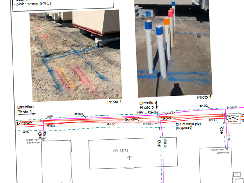
Underground Service Location
- Locate all underground services with ground penetrating radar (GPR) and potholing if requested
- Survey all underground services and provide information in Easting, Northing and RL in the required coordinate system.
Who we've worked with


